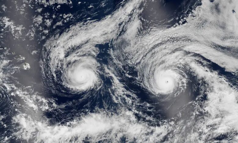
A striking satellite image captured nearly a decade ago offers a vivid reminder of a rare meteorological alignment when two powerful hurricanes barreled simultaneously toward Hawaii. Taken on August 29, 2016, by the Suomi NPP satellite, the photograph shows Hurricane Madeline on the left and Hurricane Lester on the right, their swirling cloud structures creating an eerily symmetrical appearance resembling a face staring upward into space.
The twin cyclones formed part of the active 2016 Pacific hurricane season, which tied as the sixth-most-active year on record with a total of 22 named storms. Hurricane Madeline was the 14th named storm of the season, while Hurricane Lester was the 13th. Both systems intensified into major hurricanes, with Madeline peaking as a Category 4 storm on August 30 and reaching maximum sustained wind speeds of approximately 130 mph, or 210 km/h. Lester also briefly reached Category 4 status on September 1, attaining maximum winds just below Madeline’s peak before rapidly weakening to a Category 3.
On August 30, the day after the satellite photo was captured, Madeline positioned itself just under 400 miles, or 650 kilometers, from Hawaii’s Big Island, while Lester tracked roughly 900 miles, or 1,450 kilometers, behind on a similar trajectory. At the time, forecasters monitoring the systems through spaceborne observations and weather models expressed uncertainty over whether either storm would strike the islands. The Central Pacific Hurricane Center subsequently issued a hurricane warning for the state, cautioning that Madeline in particular would pass dangerously close to the Big Island.
Despite the close approach, neither storm made landfall, meaning the eye of neither system passed directly over a landmass. In the historical satellite photo, the Big Island itself is obscured by reflected sunlight known as sunglint along the left side of the frame. Madeline eventually passed south of Hawaii on August 31, by which point it had weakened to a Category 1 storm. Lester followed by passing north of the Big Island on September 2, coming within about 130 miles, or 210 kilometers, of Honolulu before executing a sharp northward turn and eventually dissipating.

Although neither hurricane made a direct landfall, their proximity still generated high winds, heavy rainfall, and strong surf across parts of the state. Meteorological experts note that Hawaii historically benefits from a degree of geographical good fortune when facing Pacific storms. The islands are typically shielded by a persistent area of high pressure situated on their eastern flank, where the majority of storms originate, alongside strong upper-level winds blowing eastward across the archipelago. These combined environmental factors frequently divert approaching systems away from a direct collision.
Nevertheless, scientists and researchers continue to evaluate how shifting global weather patterns and rising temperatures could influence future storm tracks in the region. Past close calls, such as the approach of Hurricane Kiko, demonstrate the ongoing vulnerability of island infrastructure to high surf, gusty winds, and coastal disruptions even when storms skirt past without making landfall.