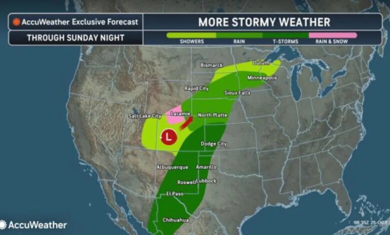
A persistent, slow-moving storm system that has spent the past week drenching Southern California and triggering flash floods across the desert Southwest is entering its final, colder phase. Forecasters warn that while the system is beginning to wind down over the Plains, it retains enough potency to deliver heavy rainfall, severe thunderstorms, and the first significant snowfall of the season to parts of the northern Rockies and the Dakotas.
Through the remainder of the weekend, the storm is expected to produce additional pockets of heavy rain across Colorado and New Mexico, as well as adjacent areas of the central and southern Plains. Meteorologist Brandon Buckingham noted that the storm has plenty of potency left to aggravate existing conditions or lead to new flooding in these regions. Rainfall totals between Saturday and Sunday evening are projected to reach 1 to 4 inches in many areas, though localized rainfall could climb as high as 10 inches where downpours persist or repeat.
The risk of flash flooding remains high, particularly in hilly terrain and desert landscapes where runoff can accumulate in a matter of minutes. Meteorologists are especially concerned about recent wildfire burn scars, which are highly susceptible to mudslides and debris flows when subjected to high-intensity rain. While the storm’s heaviest precipitation is expected to avoid the Denver metropolitan area and the majority of the Colorado River basin, some runoff is still expected to enter the river system, potentially providing a minor boost to water levels over the coming weeks.
As the system tracks toward the Dakotas, eastern Montana, and western Minnesota, it will pull in colder air, transitioning from rain to a wet, heavy snow. This shift is expected to occur between Sunday night and Monday night. Meteorologist Bob Smerbeck indicated there is potential for several inches of snow to fall over the Black Hills of South Dakota. Slushy accumulations are also possible in lower-elevation areas such as Rapid City, where the heaviest snowfall is anticipated on Monday, primarily affecting unpaved surfaces.

The footprint of the season’s first snow is expected to extend from eastern Wyoming and northwestern Nebraska to parts of southwestern North Dakota. This wintry transition marks a sharp contrast to the conditions seen earlier in the week when the system was primarily a rain-producer.
Meanwhile, on the southern edge of the system, the threat of severe weather persists. The storm has a history of producing damaging wind gusts and hail, and these remain the primary concerns for New Mexico and West Texas through Monday evening. Forecasters have not ruled out the possibility of brief, isolated tornadoes forming within the most intense cells as the system moves through the region.

The arrival of moisture is a mixed blessing for a region still grappling with significant environmental challenges. Major to record-level flooding has already occurred along sections of the San Juan River in northern New Mexico. Conversely, much of the territory between the Rockies and the Great Basin remains under moderate to exceptional drought conditions. Only a narrow corridor—stretching from eastern Colorado and northern Kansas into southeastern Nebraska and much of Iowa—has received sufficient summer and early autumn rain to move out of drought status. For the rest of the Plains, the coming moisture may provide some relief, even as it brings the threat of immediate flooding.