As the calendar turns toward winter, a developing El Niño continues to exert a profound influence on weather patterns across the Lower 48 states, shaping a November outlook that points to delayed winter conditions for millions of residents, while offering early signs of seasonal change to others.
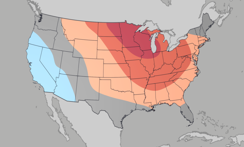
Temperature projections show distinct regional variations driven by the ongoing climate phenomenon. The most pronounced above-average temperatures are anticipated across parts of the upper Midwest and the Great Lakes. This region, stretching from the Dakotas through northern Indiana and highlighted by the darkest red indicators on meteorological maps, is expected to experience the strongest warmth relative to seasonal norms for the month. These above-average conditions extend broadly from the Northern Plains across most of the Mississippi and Ohio River valleys, stretching all the way into the interior Northeast.
Additional regions slated for slightly above-average warmth include the eastern Rockies, the Four Corners region, most of the Southern Plains, the Southeast, and major urban centers situated along the Interstate 95 corridor. Meanwhile, temperatures are expected to hover near seasonal averages across New England, Florida, the southern portions of Louisiana and Texas, and the corridor extending through the Rockies to the Pacific Northwest. In contrast, the only region projected to experience below-average temperatures encompasses California alongside portions of Oregon, Nevada, Arizona, and Utah.
Precipitation forecasts similarly reflect the reach of El Niño, with the vast majority of the Lower 48 anticipating near-average moisture levels. However, notable localized deviations are projected. The Pacific Northwest stands out as the sole area expected to see below-average precipitation for the month. Conversely, the soggiest conditions are forecasted to stretch across a broad corridor from the Gulf Coast of Texas all the way to the Atlantic coast of Maryland.

Slightly above-average precipitation is also anticipated to impact areas ranging from California and the southern portions of New Mexico and Arizona to a vast expanse stretching from Texas upward to southern New Hampshire. For residents in the West, these wet trends may provide a welcome sense of seasonal weather if precipitation patterns persist in the coming months.
While the meteorological patterns currently unfolding bear many hallmarks of a record El Niño, forecasters note that the developing system does not yet match every traditional benchmark of a standard El Niño winter. Typical historical patterns often feature warmer and drier conditions across the northern tier, drier weather in the Midwest, and increased wetness across the South. Although this year’s progression is still evolving, the existing similarities are already dictating the month-to-month climate expectations for communities nationwide.