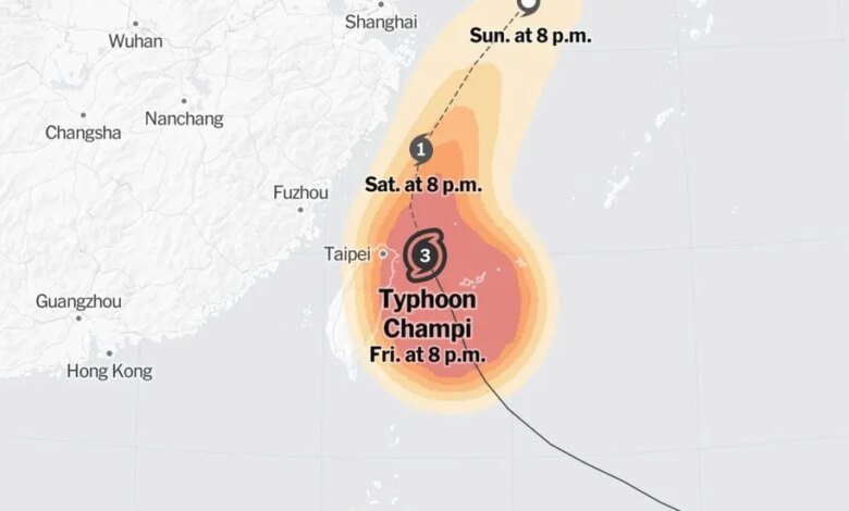
Super Typhoon Champi has surged into the most powerful tropical cyclone of 2026 by maximum sustained wind speed, achieving a peak intensity approaching 185 miles per hour over the Philippine Sea.
National Weather Service data indicates that the storm attained Category 5 hurricane equivalence on Wednesday morning local time, positioning itself east of the Philippines and southeast of Taiwan. Champi’s rapid development began after it formed as a tropical storm last Thursday, escalating into the equivalent of a Category 4 hurricane in less than 48 hours before tracking northwestward across the Pacific Ocean and passing within 10 miles of Guam on Saturday.
This week’s peak marks the third time Champi has reached Category 5 strength during its lifecycle. The storm first achieved the milestone six hours after clearing Guam on October 17, registering sustained winds near 165 mph. Following a brief period of weakening, it rebounded to Category 5 intensity the following day before climbing to its current maximum sustained winds—defined as the highest average wind speed recorded over a continuous minute.
While Champi surpassed the 180 mph peak set by Hurricane Polo off Mexico in September, it remains shy of the all-time 215 mph record established by Hurricane Patricia in 2015. Additionally, Hurricane Polo retains a separate intensity metric for the year, having recorded a lower minimum central pressure of 892 millibars compared to Champi’s 895 millibars. Lower central pressure measurements generally signal a stronger storm system, serving as an alternative benchmark for meteorologists evaluating cyclone severity.
Signs of degradation emerged Wednesday as Champi began to lose steam over the Philippine Sea. The Joint Typhoon Warning Center reported that maximum sustained winds had dropped to just over 170 mph. Forecasters anticipate continued weakening in the coming days as the typhoon tracks northwestward over cooler ocean waters.
Uncertainty remains regarding the storm’s ultimate trajectory. Diverging computer forecast models suggest two primary paths, with some simulations pointing toward Taiwan and mainland China, while others project a northeastward turn toward Japan.